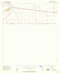
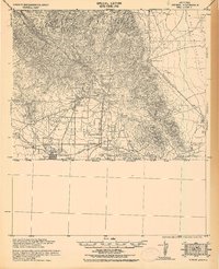
1957 Map of Paul Spur
USGS Topo · Published 1959About this map
Paul Spur and the surrounding reaches of the Sulphur Spring Valley define this borderlands landscape just north of the international boundary between the United States and Mexico. The map captures an era of industrial and transportation utility, anchored by the east-west corridor of the Southern Pacific railroad. Near the settlement of Forrest, the infrastructure of the Forrest Airport and a series of reservoirs illustrate the management of resources and transit in this arid environment. To the west, the landscape is marked by more localized activity, including a Quarry and a Cemetery near Paul Spur, alongside the residential footprint of Rancho San Jose. Multiple landing strips and a prominent pipeline further indicate the region's importance for logistics and utility networks during the mid-century period.
Find a feature on this map
14 named features on this map. Tap any name to fly to it.
Don’t see what you’re looking for? This feature index may not catch every label — zoom into the map to look around manually.
Map Details
Editions of this 1957 Paul Spur Map
3 editions found
Other maps of this area

1902 · Bisbee
USGS Topo · 1:62,500

1910 · Bisbee
USGS Topo · 1:62,500

1914 · Douglas
USGS Topo · 1:62,500

1916 · Douglas
USGS Topo · 1:125,000

1919 · Douglas
USGS Topo · 1:125,000

1925 · Douglas
USGS Topo · 1:62,500

1927 · Bisbee
USGS Topo · 1:62,500
1933 · Douglas
USGS Topo · 1:62,500
1933 · Bisbee
USGS Topo · 1:62,500

1955 · Douglas
USGS Topo · 1:250,000