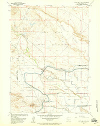
1958 Map of Pavillion Butte
USGS Topo · Published 1959About this map
The Wind River Indian Reservation landscape is defined by the intersection of natural river systems and mid-century federal water management projects. At the heart of this 1958 survey, the Wind River and Fivemile Creek are harnessed by an extensive network of irrigation infrastructure, including the Wyoming Canal, Pavillion Main Lateral, and various siphons and gaging stations. These developments fall within the Riverton Reclamation Withdrawal Area, illustrating the Bureau of Reclamation's efforts to transform this arid Wyoming terrain into productive agricultural land. Distinctive geological markers like Muddy Ridge, Pavillion Ridge, and the namesake Pavillion Butte provide topographic contrast to the leveled fields. Near the southern edge, the Pavillion Airport and several Gravel Pits indicate the local infrastructure and industry supporting the community during the post-war development of the Missouri River Basin.
Find a feature on this map
20 named features on this map. Tap any name to fly to it.
Don’t see what you’re looking for? This feature index may not catch every label — zoom into the map to look around manually.
Map Details
Editions of this 1958 Pavillion Butte Map
2 editions found
Other maps of this area

1950 · Pavillion
USGS Topo · 1:24,000

1950 · Pavillion Butte
USGS Topo · 1:24,000

1950 · Harris Bridge
USGS Topo · 1:24,000

1950 · Ocean Lake
USGS Topo · 1:24,000

1950 · Shotgun Butte
USGS Topo · 1:24,000

1951 · Eagle Point
USGS Topo · 1:24,000

1951 · Morton
USGS Topo · 1:24,000

1951 · Lookout Butte
USGS Topo · 1:24,000

1951 · Jenkins Mountain
USGS Topo · 1:24,000

1955 · Thermopolis
USGS Topo · 1:250,000