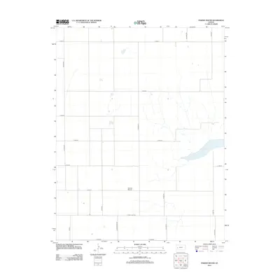
2012 Map of Pawnee Mound
USGS Topo · Published 2012About this map
Pawnee Mound rises as a subtle landmark in this section of Finney County, Kansas, where the high plains landscape is dominated by a strict grid of section lines and gravel roads. In this semi-arid environment, the presence of Dry Lake in the eastern portion of the map suggests a transient water feature that only fills during periods of significant runoff. The transportation network is defined by roads named for regional history and indigenous groups, such as S Navaho Rd, S Shawnee Rd, and S Taos Rd. Long east-west thoroughfares like E Finney Scott Rd and E Friend Rd intersect with local routes like N Jennie Barker Rd, illustrating the systematic division of agricultural land that has characterized the region since the late nineteenth century. This map documents the rural infrastructure and natural depressions of the Kansas plains in the early twenty-first century.
Find a feature on this map
20 named features on this map. Tap any name to fly to it.
Don’t see what you’re looking for? This feature index may not catch every label — zoom into the map to look around manually.
Map Details
Editions of this 2012 Pawnee Mound Map
This is the sole edition of this map. No revisions or reprints were ever made.
Other maps of this area

1940 · Scott City
USGS Topo · 1:62,500

1944 · Tennis
USGS Topo · 1:62,500

1951 · Scott City
USGS Topo · 1:62,500

1955 · Scott City
USGS Topo · 1:250,000

1958 · Scott City
USGS Topo · 1:250,000
1974 · Scott City 4 NW
USGS Topo · 1:24,000

1974 · Amy SW
USGS Topo · 1:24,000

1974 · Grigston
USGS Topo · 1:24,000
1976 · Shallow Water
USGS Topo · 1:24,000
1976 · Tennis
USGS Topo · 1:24,000