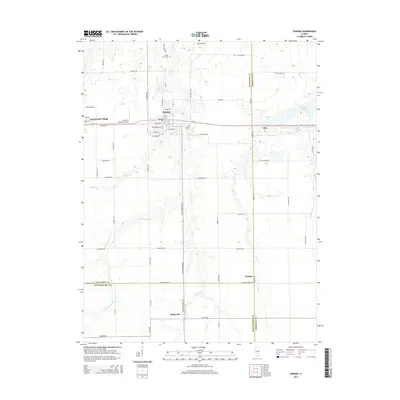
2015 Map of Pawnee
USGS Topo · Published 2015About this map
Pawnee serves as the primary hub in this central Illinois landscape, situated at the junction of Horse Cr and several regional routes. The map documents the intricate drainage patterns of the area, including the winding Henkle Br and W Br Horse Cr which feed into the larger creek systems. These waterways historically influenced the placement of early settlements and agricultural boundaries throughout Sangamon, Christian, and Montgomery counties.
Find a feature on this map
68 named features on this map. Tap any name to fly to it.
Don’t see what you’re looking for? This feature index may not catch every label — zoom into the map to look around manually.
Map Details
Editions of this 2015 Pawnee Map
This is the sole edition of this map. No revisions or reprints were ever made.
Other maps of this area

1922 · Divernon
USGS Topo · 1:62,500

1923 · Taylorville
USGS Topo · 1:62,500

1923 · Raymond
USGS Topo · 1:62,500

1924 · Divernon
USGS Topo · 1:62,500

1925 · Taylorville
USGS Topo · 1:62,500

1925 · Raymond
USGS Topo · 1:62,500

1946 · Nokomis
USGS Topo · 1:62,500

1949 · Nokomis
USGS Topo · 1:62,500

1958 · Decatur
USGS Topo · 1:250,000
1961 · New City
USGS Topo · 1:24,000