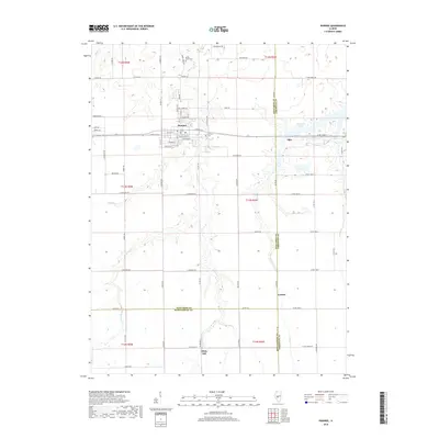
2018 Map of Pawnee
USGS Topo · Published 2018About this map
Pawnee serves as the primary hub of this landscape where the borders of Sangamon, Christian, and Montgomery Counties converge. The village is well-defined by a grid of streets including Lincoln St and Carroll St, with local history anchored at the Calvary Cem and the nearby Horse Creek Cem. To the east, the western reaches of Sangchris Lake introduce a complex shoreline into the otherwise orderly agricultural sections of the Illinois prairie. Small settlements like Ellis and Zenobia mark the intersections of rural county roads, such as Ratliff Rd and E Boarman Rd. The terrain is deeply etched by a network of waterways including Horse Cr, Brush Cr, and Clear Cr, which dictate the placement of farmsteads and old timber stands along their banks.
Find a feature on this map
53 named features on this map. Tap any name to fly to it.
Don’t see what you’re looking for? This feature index may not catch every label — zoom into the map to look around manually.
Map Details
Editions of this 2018 Pawnee Map
This is the sole edition of this map. No revisions or reprints were ever made.
Other maps of this area

1922 · Divernon
USGS Topo · 1:62,500

1923 · Taylorville
USGS Topo · 1:62,500

1923 · Raymond
USGS Topo · 1:62,500

1924 · Divernon
USGS Topo · 1:62,500

1925 · Taylorville
USGS Topo · 1:62,500

1925 · Raymond
USGS Topo · 1:62,500

1946 · Nokomis
USGS Topo · 1:62,500

1949 · Nokomis
USGS Topo · 1:62,500

1958 · Decatur
USGS Topo · 1:250,000
1961 · New City
USGS Topo · 1:24,000