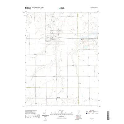
2021 Map of Pawnee
USGS Topo · Published 2021About this map
Pawnee serves as the primary population center in this Central Illinois landscape, where the town grid is defined by streets like Lincoln St and Jefferson St. The surrounding countryside is a study in rural organization, heavily partitioned by a network of county roads such as Co Hwy 50 and Cotton Hill Rd. These routes connect smaller locales and rural clusters, including Ellis, Zenobia, and White Oak, illustrating the persistent settlement patterns of the region.
Find a feature on this map
70 named features on this map. Tap any name to fly to it.
Don’t see what you’re looking for? This feature index may not catch every label — zoom into the map to look around manually.
Map Details
Editions of this 2021 Pawnee Map
This is the sole edition of this map. No revisions or reprints were ever made.
Other maps of this area

1922 · Divernon
USGS Topo · 1:62,500

1923 · Taylorville
USGS Topo · 1:62,500

1923 · Raymond
USGS Topo · 1:62,500

1924 · Divernon
USGS Topo · 1:62,500

1925 · Taylorville
USGS Topo · 1:62,500

1925 · Raymond
USGS Topo · 1:62,500

1946 · Nokomis
USGS Topo · 1:62,500

1949 · Nokomis
USGS Topo · 1:62,500

1958 · Decatur
USGS Topo · 1:250,000
1961 · New City
USGS Topo · 1:24,000