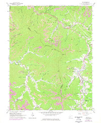
1965 Map of Pax
USGS Topo · Published 1977About this map
Paint Mountain and the deep valleys of Paint Creek define this section of the West Virginia coalfields during a period of industrial transition. The landscape is marked by the infrastructure of extraction, featuring numerous strip mines, a Tipple, and mine dumps clustered near settlements like Kingston and Milburn. The West Virginia Turnpike cuts through the ridges, intersecting with local history at Interchange 4 near East Kingston.
Find a feature on this map
112 named features on this map. Tap any name to fly to it.
Don’t see what you’re looking for? This feature index may not catch every label — zoom into the map to look around manually.
Map Details
Editions of this 1965 Pax Map
3 editions found
Other maps of this area

1891 · Raleigh
USGS Topo · 1:125,000

1897 · Kanawha Falls
USGS Topo · 1:125,000

1897 · Raleigh
USGS Topo · 1:125,000

1900 · Kanawha Falls
USGS Topo · 1:125,000

1901 · Kanawha Falls
USGS Topo · 1:125,000

1902 · Raleigh
USGS Topo · 1:125,000

1908 · Fayetteville
USGS Topo · 1:48,000

1908 · Montgomery
USGS Topo · 1:48,000

1910 · Fayetteville
USGS Topo · 1:62,500

1910 · Montgomery
USGS Topo · 1:62,500