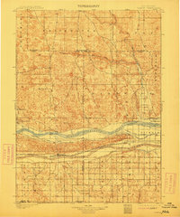
1901 Map of Paxton
USGS Topo · Published 1912About this map
The North Platte River and South Platte River converge in this late-nineteenth-century survey, revealing a landscape defined by the arrival of the Union Pacific R. R. and early irrigation efforts. Settled along the rail corridor, the town of Paxton serves as a central hub between the river forks. To the north, the terrain transitions into the sandhills, where isolated outposts like Knights Ranch, Duck Brand Ranch, and Linn Ranch represent the cattle ranching economy of the era.
Find a feature on this map
34 named features on this map. Tap any name to fly to it.
Don’t see what you’re looking for? This feature index may not catch every label — zoom into the map to look around manually.
Map Details
Editions of this 1901 Paxton Map
4 editions found
Other maps of this area

1897 · Ogallala
USGS Topo · 1:125,000

1898 · Paxton
USGS Topo · 1:125,000

1899 · North Platte
USGS Topo · 1:125,000

1900 · Ogallala
USGS Topo · 1:125,000

1901 · Paxton
USGS Topo · 1:125,000

1902 · North Platte
USGS Topo · 1:125,000

1949 · Arthur
USGS Topo · 1:62,500

1949 · Flats
USGS Topo · 1:62,500

1949 · Wright Valley
USGS Topo · 1:62,500

1950 · Flats
USGS Topo · 1:62,500