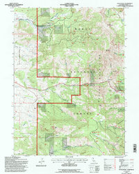
1993 Map of Payne Peak
USGS Topo · Published 1996About this map
The Warner Mountains dominate this high-altitude landscape within the Modoc National Forest, showcasing a complex network of canyons and peaks during the early 1990s. The terrain is defined by dramatic elevation changes, from the prominent Payne Peak to the deep Summit Canyon and Smalls Canyon. This survey records specific recreational and utility infrastructure, including the Cedar Pass Ski Area and a Radio Facility located west of the main range. Water management and natural drainage patterns are clearly visible through features like the Stough Reservoir and the Joseph Creek Basin, where numerous Springs feed into creeks such as Thoms Creek and Mile Cantrall Creek. The map provides a detailed view of the Cedar Pass corridor, a critical transit point through the rugged crest that has long served as a gateway across Modoc County.
Find a feature on this map
39 named features on this map. Tap any name to fly to it.
Don’t see what you’re looking for? This feature index may not catch every label — zoom into the map to look around manually.
Map Details
Editions of this 1993 Payne Peak Map
This is the sole edition of this map. No revisions or reprints were ever made.
Other maps of this area

1886 · Alturas
USGS Topo · 1:250,000

1892 · Alturas
USGS Topo · 1:250,000

1954 · Alturas
USGS Topo · 1:250,000

1958 · Alturas
USGS Topo · 1:250,000

1962 · Alturas
USGS Topo · 1:250,000

1962 · Davis Creek
USGS Topo · 1:62,500

1962 · Cedarville
USGS Topo · 1:62,500

1963 · Warren Peak
USGS Topo · 1:24,000

1963 · Shields Creek
USGS Topo · 1:24,000

1963 · Dorris Reservoir
USGS Topo · 1:24,000