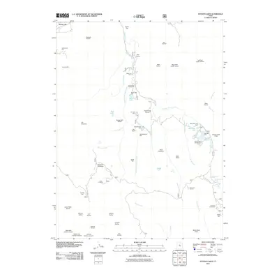
2011 Map of Payson Lakes
USGS Topo · Published 2011About this map
Golden Relief Mine and the Syndicate Mine sit on the western slopes of Dry Mountain in this 2011 topographic record of the canyon country south of Payson. The landscape is defined by its recreation and water management systems, including the Maple Dell Camp and Camp Koholowo, alongside several reservoirs such as Big East Reservoir and McClellan Lake. Numerous small dams, including the Maple Lake Dam and Pete Winward Dam, manage the flow of Peteetneet Creek and its tributaries as they descend through named canyons like Bear Canyon and Frank Young Canyon. This survey documents the intersection of industrial history and modern public land use, showing established sites like the Payson Lakes Campground and Blackhawk Campground near family-named landmarks like the Minnie Simmons Spring and Wimmer Ranch Creek.
Find a feature on this map
72 named features on this map. Tap any name to fly to it.
Don’t see what you’re looking for? This feature index may not catch every label — zoom into the map to look around manually.
Map Details
Editions of this 2011 Payson Lakes Map
This is the sole edition of this map. No revisions or reprints were ever made.
Other maps of this area

1885 · Salt Lake
USGS Topo · 1:250,000

1885 · Manti
USGS Topo · 1:250,000

1895 · Manti
USGS Topo · 1:250,000

1948 · Spanish Fork
USGS Topo · 1:24,000

1949 · Provo
USGS Topo · 1:62,500

1949 · Spanish Fork Peak
USGS Topo · 1:24,000

1950 · Spanish Fork
USGS Topo · 1:24,000

1950 · West Mountain
USGS Topo · 1:24,000
1950 · West Mountain
USGS Topo · 1:62,500

1951 · Spanish Fork Peak
USGS Topo · 1:24,000