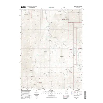
2014 Map of Payson Lakes
USGS Topo · Published 2014About this map
Uinta National Forest lands dominate this high-elevation landscape, where the northern slopes of the Wasatch Range meet the settled valley floors near Spring Lake and Santaquin. The map highlights a complex network of canyons and peaks, including Dry Mtn and the steep reaches of Loafer Canyon. Water resources are a central theme of this 2014 survey, from the high alpine waters of Payson Lakes and Lizard Lake to the drainage of Peteetneet Creek. Recreational infrastructure is well-established throughout the mountainous terrain, evidenced by several organized sites such as Payson Lakes Campground, Maple Dell Camp, and Camp Koholowo. Local history and family names are preserved through landmarks like Minnie Simmons Spring, Wimmer Ranch Creek, and Frank Young Canyon, offering clear evidence of past ranching and land use within the forest boundaries. The survey captures the interface between modern residential growth in Woodland Hills and the protected wilderness areas of the canyon country.
Find a feature on this map
90 named features on this map. Tap any name to fly to it.
Don’t see what you’re looking for? This feature index may not catch every label — zoom into the map to look around manually.
Map Details
Editions of this 2014 Payson Lakes Map
This is the sole edition of this map. No revisions or reprints were ever made.
Other maps of this area

1885 · Salt Lake
USGS Topo · 1:250,000

1885 · Manti
USGS Topo · 1:250,000

1895 · Manti
USGS Topo · 1:250,000

1948 · Spanish Fork
USGS Topo · 1:24,000

1949 · Provo
USGS Topo · 1:62,500

1949 · Spanish Fork Peak
USGS Topo · 1:24,000

1950 · Spanish Fork
USGS Topo · 1:24,000

1950 · West Mountain
USGS Topo · 1:24,000
1950 · West Mountain
USGS Topo · 1:62,500

1951 · Spanish Fork Peak
USGS Topo · 1:24,000