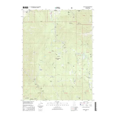
2017 Map of Payson Lakes
USGS Topo · Published 2017About this map
Uinta National Forest lands dominate the high elevations of the Wasatch Range south of Payson, where a complex system of canyons and reservoirs defines the drainage pattern. The landscape is marked by the steep descents of Payson Canyon and Loafer Canyon, which funnel water toward the northern settlements. Modern developments like Woodland Hills and Santaquin Meadows sit on the fringe of the rugged mountain front, while the interior is managed for recreation and resource conservation. Notable water features such as Payson Lakes, Pete Winward Reservoir, and the Dry Lake Reservoir are connected by the winding Nebo Loop road, providing access to landmarks like Amos Backbone and the Grotto. The map details the transition from residential periphery to protected forest wilderness, tracing the legacy of irrigation and water management through numerous springs and creeks.
Find a feature on this map
89 named features on this map. Tap any name to fly to it.
Don’t see what you’re looking for? This feature index may not catch every label — zoom into the map to look around manually.
Map Details
Editions of this 2017 Payson Lakes Map
This is the sole edition of this map. No revisions or reprints were ever made.
Other maps of this area

1885 · Salt Lake
USGS Topo · 1:250,000

1885 · Manti
USGS Topo · 1:250,000

1895 · Manti
USGS Topo · 1:250,000

1948 · Spanish Fork
USGS Topo · 1:24,000

1949 · Provo
USGS Topo · 1:62,500

1949 · Spanish Fork Peak
USGS Topo · 1:24,000

1950 · Spanish Fork
USGS Topo · 1:24,000

1950 · West Mountain
USGS Topo · 1:24,000
1950 · West Mountain
USGS Topo · 1:62,500

1951 · Spanish Fork Peak
USGS Topo · 1:24,000