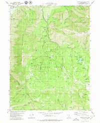
1979 Map of Payson Lakes
USGS Topo · Published 1979About this map
The high ridges of Mount Nebo and Loafer Mountain dominate this late 1970s survey, illustrating the complex geography of the Uinta National Forest. The landscape is a mix of high-altitude recreation and industrial extraction, with active and former resource sites like the Golden Relief Mine and Syndicate Mine positioned alongside numerous mountain camps. Small alpine water bodies, including Maple Lake, Red Lake, and the larger Big East Lake, are scattered throughout the peaks, while the High Line Canal skirts the northern edge near the settlement of Spring Lake. The distribution of family-named agricultural holdings, such as Wimmer Ranch and Jones Ranch, alongside the Payson Lake Guard Sta, shows the historic transition between private land use and federal forest management.
Find a feature on this map
76 named features on this map. Tap any name to fly to it.
Don’t see what you’re looking for? This feature index may not catch every label — zoom into the map to look around manually.
Map Details
Editions of this 1979 Payson Lakes Map
This is the sole edition of this map. No revisions or reprints were ever made.
Other maps of this area

1885 · Salt Lake
USGS Topo · 1:250,000

1885 · Manti
USGS Topo · 1:250,000

1895 · Manti
USGS Topo · 1:250,000

1948 · Spanish Fork
USGS Topo · 1:24,000

1949 · Provo
USGS Topo · 1:62,500

1949 · Spanish Fork Peak
USGS Topo · 1:24,000

1950 · Spanish Fork
USGS Topo · 1:24,000

1950 · West Mountain
USGS Topo · 1:24,000
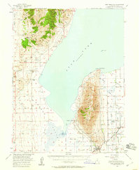
1950 · West Mountain
USGS Topo · 1:62,500

1951 · Spanish Fork Peak
USGS Topo · 1:24,000