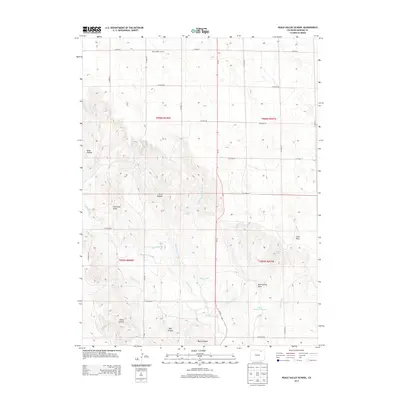
2013 Map of Peace Valley School
USGS Topo · Published 2013About this map
Peace Valley School stands as a focal point in this portion of Morgan County, marking a localized center of community in a landscape defined by an extensive network of county roads and water management features. The terrain is deeply incised by a series of drainages and canyons, including Allan Canyon, Echo Canyon, and Porter Canyon, which suggest a complex system of seasonal water flow through this high plains environment. Water rights and agricultural management are evident through the presence of Jackpot Ditch, which winds through the central and southern sections, and Bettale Reservoir Number 1 located near the southeastern corner. These man-made water features, alongside natural sources like East Prong Spring and Rock Spring, highlight the essential nature of water control for the homesteads and ranches that historically occupied this region. The map also records several distinctive landforms, such as the Twin Hills and Lone Tree Draw, which served as reliable landmarks for residents navigating the rural grid.
Find a feature on this map
35 named features on this map. Tap any name to fly to it.
Don’t see what you’re looking for? This feature index may not catch every label — zoom into the map to look around manually.
Map Details
Editions of this 2013 Peace Valley School Map
This is the sole edition of this map. No revisions or reprints were ever made.
Other maps of this area

1951 · Weldona
USGS Topo · 1:24,000

1951 · Dead Horse Springs
USGS Topo · 1:24,000

1951 · Brush West
USGS Topo · 1:24,000

1951 · Peace Valley School
USGS Topo · 1:24,000

1951 · Judson Hills
USGS Topo · 1:24,000

1951 · Fort Morgan
USGS Topo · 1:24,000

1954 · Sterling
USGS Topo · 1:250,000

1958 · Sterling
USGS Topo · 1:250,000
1971 · Brush West
USGS Topo · 1:24,000
1971 · Fort Morgan
USGS Topo · 1:24,000