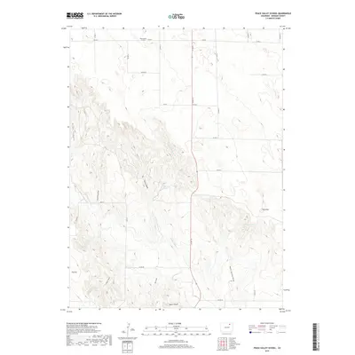
2019 Map of Peace Valley School
USGS Topo · Published 2019About this map
Peace Valley School sits in the northern reaches of Morgan County, serving as a focal point for a landscape defined by its complex drainage network and agricultural infrastructure. The topography is marked by numerous seasonal watercourses and breaks, including Allan Canyon and Echo Canyon which feed into the E Prong Wildcat Cr. Water management is evident through the presence of the Jackpot Ditch and local water sources like East Prong Spring and Rock Spring, which were critical for ranching in this arid environment.
Find a feature on this map
35 named features on this map. Tap any name to fly to it.
Don’t see what you’re looking for? This feature index may not catch every label — zoom into the map to look around manually.
Map Details
Editions of this 2019 Peace Valley School Map
This is the sole edition of this map. No revisions or reprints were ever made.
Other maps of this area

1951 · Weldona
USGS Topo · 1:24,000

1951 · Dead Horse Springs
USGS Topo · 1:24,000

1951 · Brush West
USGS Topo · 1:24,000

1951 · Peace Valley School
USGS Topo · 1:24,000

1951 · Judson Hills
USGS Topo · 1:24,000

1951 · Fort Morgan
USGS Topo · 1:24,000

1954 · Sterling
USGS Topo · 1:250,000

1958 · Sterling
USGS Topo · 1:250,000
1971 · Brush West
USGS Topo · 1:24,000
1971 · Fort Morgan
USGS Topo · 1:24,000