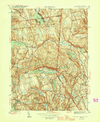
1945 Map of Peach Lake
USGS Topo · Published 1945About this map
Peach Lake and the surrounding chain of glacial water bodies dominate this mid-century landscape along the border of Putnam and Westchester Counties. The survey reveals a region defined by its hydrography and small, concentrated settlements like North Salem, Salem Center, and South Salem. To the west, the Titicus Reservoir serves as a major landmark, fed by the Titicus River and Titicus Brook. Further south, a dense cluster of lakes including Lake Waccabuc, Lake Rippowam, and Lake Oscaleta illustrates the recreational and residential draw of the area during the 1940s.
Find a feature on this map
46 named features on this map. Tap any name to fly to it.
Don’t see what you’re looking for? This feature index may not catch every label — zoom into the map to look around manually.
Map Details
Editions of this 1945 Peach Lake Map
3 editions found
Other maps of this area

1892 · Stamford
USGS Topo · 1:62,500

1892 · Danbury
USGS Topo · 1:62,500

1892 · Norwalk
USGS Topo · 1:62,500

1892 · Carmel
USGS Topo · 1:62,500

1893 · Carmel
USGS Topo · 1:62,500

1893 · Stamford
USGS Topo · 1:62,500

1893 · Norwalk
USGS Topo · 1:62,500

1894 · Carmel
USGS Topo · 1:62,500

1899 · Stamford
USGS Topo · 1:62,500

1915 · Danbury
USGS Topo · 1:62,500