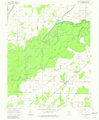
1964 Map of Peach Orchard
USGS Topo · Published 1981About this map
The Black River and Little River define the intricate hydrological character of this 1964 survey, where the two rivers meander through a dense network of sloughs and cutoffs. The sprawling State Game Area dominates the central landscape, preserving a wilderness of named water bodies like Murphy Lake, Mill Lake, and Woodland Slough. This fluvial environment stands in contrast to the agricultural and rail-oriented settlements on the periphery. To the east, the Missouri Pacific line connects the town of Peach Orchard, while the northwestern corner shows Reyno positioned along the St Louis-San Francisco RR. For genealogists, the map preserves the exact locations of family-named landmarks and rural institutions, including Nelson Cem, Allen Cem, and Pirtle Ch, alongside the small community of Brookings nestled near the river's edge.
Find a feature on this map
40 named features on this map. Tap any name to fly to it.
Don’t see what you’re looking for? This feature index may not catch every label — zoom into the map to look around manually.
Map Details
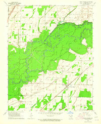
Editions of this 1964 Peach Orchard Map
3 editions found
Other maps of this area

1932 · Walnut Ridge
USGS Topo · 1:62,500

1935 · Knobel
USGS Topo · 1:62,500

1935 · Reyno
USGS Topo · 1:62,500

1935 · Walnut Ridge
USGS Topo · 1:62,500

1940 · Gainesville
USGS Topo · 1:62,500

1941 · Knobel
USGS Topo · 1:62,500

1957 · Poplar Bluff
USGS Topo · 1:250,000

1958 · Gainesville
USGS Topo · 1:62,500

1959 · Poplar Bluff
USGS Topo · 1:250,000
1960 · Gainesville
USGS Topo · 1:62,500