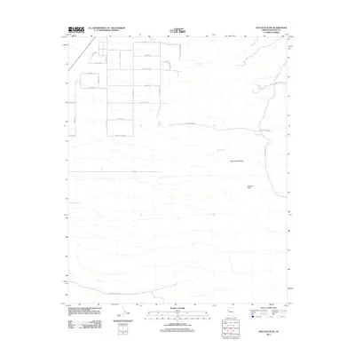
2011 Map of Peacock Peak
USGS Topo · Published 2011About this map
Peacock Peak and the high ridges of the Peacock Mountains dominate this 2011 Mohave County landscape, where the arid environment is defined by its scattered water sources. Vital desert springs like Crescent Spring, Willow Spring, and Mine Spring are essential landmarks in a region where local ranching and transit rely on dependable water. A grid of residential and utility roads, including Olympic Ave and Zephon Dr, suggests localized development or rural division north of the main mountain mass. Ranching heritage is evidenced by the presence of Happy Trails Rnch and established routes such as Mount Ranch Rd and Grounds Ranch Rd. This survey documents a transitional period of rural land use, balancing traditional desert ranching with modern road infrastructure like Elk Run Rd and Spring Valley Dr.
Find a feature on this map
35 named features on this map. Tap any name to fly to it.
Don’t see what you’re looking for? This feature index may not catch every label — zoom into the map to look around manually.
Map Details
Editions of this 2011 Peacock Peak Map
This is the sole edition of this map. No revisions or reprints were ever made.
Other maps of this area

1886 · Diamond Creek
USGS Topo · 1:250,000

1892 · Diamond Creek
USGS Topo · 1:250,000

1948 · Williams
USGS Topo · 1:250,000

1954 · Williams
USGS Topo · 1:250,000

1956 · Williams
USGS Topo · 1:250,000

1960 · Williams
USGS Topo · 1:250,000

1961 · Williams
USGS Topo · 1:250,000
1968 · Long Mountain
USGS Topo · 1:24,000
1968 · Kingman Airport
USGS Topo · 1:24,000
1968 · Peacock Peak
USGS Topo · 1:24,000