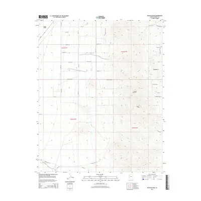
2014 Map of Peacock Peak
USGS Topo · Published 2014About this map
Peacock Peak rises as a prominent landmark within the Peacock Mountains in this modern survey of Mohave County. The landscape is defined by the transition from the high desert floor near the settlement of Valle Vista to the more varied terrain of the mountain range to the east. Historically significant water sources are scattered throughout the highlands, including Crescent Spring, Willow Spring, and Mine Spring, which have long supported ranching and travel in this arid environment. The road network reflects both the modern residential growth of Valle Vista and the older routes of the region, such as Az-66 and Grounds Ranch Rd. Near the eastern edge of the map, the small community of Hackberry sits tucked into the slopes, illustrating the persistent clusters of human habitation in a region defined by its hydrology and mountain passes.
Find a feature on this map
41 named features on this map. Tap any name to fly to it.
Don’t see what you’re looking for? This feature index may not catch every label — zoom into the map to look around manually.
Map Details
Editions of this 2014 Peacock Peak Map
This is the sole edition of this map. No revisions or reprints were ever made.
Other maps of this area

1886 · Diamond Creek
USGS Topo · 1:250,000

1892 · Diamond Creek
USGS Topo · 1:250,000

1948 · Williams
USGS Topo · 1:250,000

1954 · Williams
USGS Topo · 1:250,000

1956 · Williams
USGS Topo · 1:250,000

1960 · Williams
USGS Topo · 1:250,000

1961 · Williams
USGS Topo · 1:250,000
1968 · Long Mountain
USGS Topo · 1:24,000
1968 · Kingman Airport
USGS Topo · 1:24,000

1968 · Peacock Peak
USGS Topo · 1:24,000