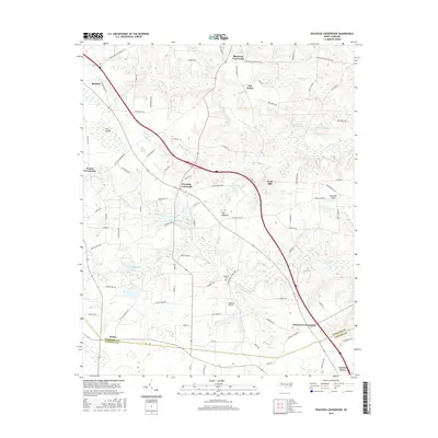
2016 Map of Peacocks Crossroads
USGS Topo · Published 2016About this map
Peacocks Crossroads and its surrounding agricultural corridor sit at the heart of this landscape, where the flat coastal plain is defined by an intricate network of wetlands and small water bodies. The terrain is marked by distinctive swampy features like The Dismal, Little Dismal Swamp, and John K Swamp, which dictate the placement of roads and farmsteads. A series of community hubs, including Woods Crossroads and Glenwood Crossroads, follow the local road network through these low-lying areas.
Find a feature on this map
88 named features on this map. Tap any name to fly to it.
Don’t see what you’re looking for? This feature index may not catch every label — zoom into the map to look around manually.
Map Details
Editions of this 2016 Peacocks Crossroads Map
This is the sole edition of this map. No revisions or reprints were ever made.
Other maps of this area

1906 · Four Oaks
USGS Topo · 1:48,000

1908 · Four Oaks
USGS Topo · 1:62,500

1909 · Coharie
USGS Topo · 1:62,500

1953 · Raleigh
USGS Topo · 1:250,000

1954 · Raleigh
USGS Topo · 1:250,000

1973 · Benson
USGS Topo · 1:24,000

1973 · Dunn
USGS Topo · 1:24,000
1974 · Mingo
USGS Topo · 1:24,000
1986 · Peacocks Crossroads
USGS Topo · 1:24,000
1986 · Timothy
USGS Topo · 1:24,000
Featured Places
- Newton Grove, NC
- Peacocks Crossroads, NC
- Glenwood Crossroads, NC
- Blackmon Crossroads, NC
- Five Points, NC