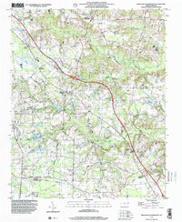
1997 Map of Peacocks Crossroads
USGS Topo · Published 2000About this map
Peacocks Crossroads and Blackmon Crossroads anchor a landscape defined by its rural intersections and agricultural drainage in the late 1990s. The region is marked by a complex network of wetlands and creeks, including the extensive John H Parker Pond Swamp and the uniquely named drainage known as The Dismal. Local community life is centered around rural institutions like the Meadow School and several country churches such as Holly Grove Ch and New Zealand Ch. This survey provides a clear view of the shifting county lines at the Johnston Co Sampson Co boundary, where it follows an Indefinite Boundary. The map also captures infrastructure developments like the Pipeline and the Interchange 334, reflecting the modernization of this agricultural corridor while naming specific family landmarks like the Barefoot Cem.
Find a feature on this map
32 named features on this map. Tap any name to fly to it.
Don’t see what you’re looking for? This feature index may not catch every label — zoom into the map to look around manually.
Map Details
Editions of this 1997 Peacocks Crossroads Map
This is the sole edition of this map. No revisions or reprints were ever made.
Other maps of this area

1906 · Four Oaks
USGS Topo · 1:48,000

1908 · Four Oaks
USGS Topo · 1:62,500

1909 · Coharie
USGS Topo · 1:62,500

1953 · Raleigh
USGS Topo · 1:250,000

1954 · Raleigh
USGS Topo · 1:250,000

1973 · Benson
USGS Topo · 1:24,000

1973 · Dunn
USGS Topo · 1:24,000
1974 · Mingo
USGS Topo · 1:24,000
1986 · Peacocks Crossroads
USGS Topo · 1:24,000
1986 · Timothy
USGS Topo · 1:24,000