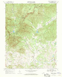
1967 Map of Peaks of Otter
USGS Topo · Published 1970About this map
The Blue Ridge crest dominates this mid-century survey, defining the rugged border between Botetourt and Bedford counties. At the heart of the landscape, the Peaks of Otter Recreation Area serves as a focal point for the Blue Ridge Parkway, which winds past high-elevation landmarks like Sharp Top Mtn and Flat Top Mtn. The terrain drops sharply from these peaks into the fertile valleys below, where the headwaters of the Big Otter River and Stony Creek supported a network of rural industry and community life in the late 1960s.
Find a feature on this map
53 named features on this map. Tap any name to fly to it.
Don’t see what you’re looking for? This feature index may not catch every label — zoom into the map to look around manually.
Map Details
Editions of this 1967 Peaks of Otter Map
3 editions found
Other maps of this area

1890 · Roanoke
USGS Topo · 1:125,000

1891 · Roanoke
USGS Topo · 1:125,000

1892 · Lynchburg
USGS Topo · 1:125,000

1894 · Natural Bridge
USGS Topo · 1:125,000

1894 · Lexington
USGS Topo · 1:125,000

1894 · Natural Bridge
USGS Topo · 1:62,500

1907 · Natural Bridge Special
USGS Topo · 1:62,500

1935 · Buena Vista
USGS Topo · 1:48,000

1939 · Buena Vista
USGS Topo · 1:62,500

1940 · Buena Vista
USGS Topo · 1:62,500