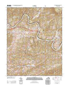
2013 Map of Pearisburg
USGS Topo · Published 2013About this map
The New River meanders sharply through the heart of this Giles County landscape, carving deep loops as it passes the settlements of Ripplemead, Norcross, and Klotz. The town of Pearisburg serves as a local hub on the western edge of the survey, while Pembroke anchors the eastern side near the confluence of Doe Cr and Little Stony Cr. This 2013 topographic study reveals a complex network of valley floors and mountain ridges, where watercourses like Walker Cr and Big Stony Creek have historically dictated the placement of small communities such as Bane and Rye Valley. Industrial history is signaled by features like the Stone Quarry Br, while the names of Smith Hollow and Mays Hollow reflect the family-centric history of the local hollows. The presence of varied terrain, from Guinea Mountain to Buckeye Mountain, illustrates the localized geography that defined regional travel before modern infrastructure.
Find a feature on this map
165 named features on this map. Tap any name to fly to it.
Don’t see what you’re looking for? This feature index may not catch every label — zoom into the map to look around manually.
Map Details
Editions of this 2013 Pearisburg Map
This is the sole edition of this map. No revisions or reprints were ever made.
Other maps of this area

1890 · Dublin
USGS Topo · 1:125,000

1891 · Dublin
USGS Topo · 1:125,000

1913 · Peterstown
USGS Topo · 1:48,000

1916 · Peterstown
USGS Topo · 1:62,500

1923 · Pearisburg
USGS Topo · 1:62,500

1925 · Peterstown
USGS Topo · 1:62,500

1932 · Peterstown
USGS Topo · 1:48,000

1932 · Pearisburg
USGS Topo · 1:48,000

1934 · Pulaski
USGS Topo · 1:48,000

1937 · Pearisburg
USGS Topo · 1:62,500