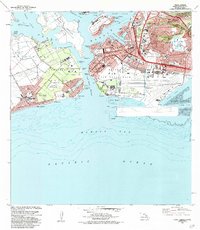
1983 Map of Pearl Harbor
USGS Topo · Published 1984About this map
Ford Island and its Naval Air Station center this detailed maritime and military landscape, where the resting places of the USS Arizona and USS Utah remain marked within the waters of Pearl Harbor. The 1980s-era topography reveals the massive scale of the Honolulu International Airport and Hickam Air Force Base, showing their seaplane runways stretching into Keehi Lagoon. Inland, the dramatic geological feature Aliamanu Crater and the nearby Salt Lake stand in contrast to the dense residential growth of Foster Village and Ewa Beach. To the west, the Waipio Peninsula Naval Reservation and Puuloa Naval Reservation dominate the coastline, including the Pacific Tsunami Warning Center and the Puuloa Rifle Range. The map illustrates a complex network of defense infrastructure and urban expansion, from the National Wildlife Refuge to the schools of Kamiloa.
Find a feature on this map
65 named features on this map. Tap any name to fly to it.
Don’t see what you’re looking for? This feature index may not catch every label — zoom into the map to look around manually.
Map Details
Editions of this 1983 Pearl Harbor Map
2 editions found
Other maps of this area

1953 · Schofield Barracks
USGS Topo · 1:24,000

1953 · Honolulu
USGS Topo · 1:24,000

1953 · Ewa
USGS Topo · 1:24,000

1953 · Puuloa
USGS Topo · 1:24,000

1954 · Oahu
USGS Topo · 1:250,000

1954 · Kaneohe
USGS Topo · 1:24,000

1954 · Waipahu
USGS Topo · 1:24,000

1959 · Kaneohe
USGS Topo · 1:24,000

1959 · Honolulu
USGS Topo · 1:24,000

1959 · Waipahu
USGS Topo · 1:24,000