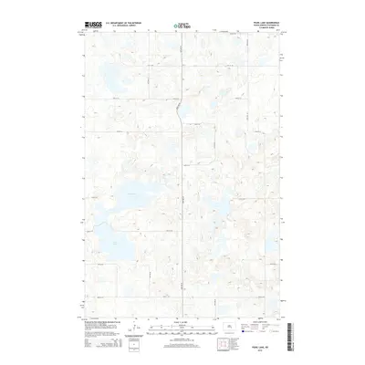
2014 Map of Pearl Lake
USGS Topo · Published 2014About this map
Pearl Lake and Mud Lake define the prairie pothole character of this Stutsman County landscape, situated within a dense network of sectional roads. The terrain is marked by numerous small, unnamed depressions and basins typical of the Missouri Coteau region, where glacial action left a complex topography of internal drainage. The 2014 survey shows a strictly organized grid of local travel, with corridors like 20th St SE and 25th St SE providing access through the undulating wetlands. The absence of concentrated settlements on this sheet highlights the agricultural and natural focus of the area, where the primary features are the large water bodies and the persistent, mile-by-mile road system that segments the North Dakota plains.
Find a feature on this map
15 named features on this map. Tap any name to fly to it.
Don’t see what you’re looking for? This feature index may not catch every label — zoom into the map to look around manually.
Map Details
Editions of this 2014 Pearl Lake Map
This is the sole edition of this map. No revisions or reprints were ever made.
Other maps of this area

1952 · New Rockford
USGS Topo · 1:250,000

1953 · Jamestown
USGS Topo · 1:250,000

1954 · Cleveland NW
USGS Topo · 1:24,000

1954 · Medina
USGS Topo · 1:24,000

1955 · Crystal Springs
USGS Topo · 1:24,000

1956 · New Rockford
USGS Topo · 1:250,000

1956 · Jamestown
USGS Topo · 1:250,000
1958 · Goldwin SW
USGS Topo · 1:24,000

1958 · Goldwin
USGS Topo · 1:24,000

1971 · New Rockford
USGS Topo · 1:250,000