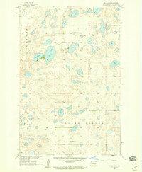
1958 Map of Goldwin SW
USGS Topo · Published 1959About this map
Glacial potholes and small water bodies dominate this prairie landscape in Stutsman County, appearing here as it was surveyed in the late 1950s. The map shows a region organized by the Public Land Survey System, with townships like Strong, Paris, Valley Spring, and Iosco defining the local geography. Human settlement is sparse but structured around local institutions, notably Medina Ch and the adjacent cemetery in the southern portion of the sheet. Education in this rural environment is represented by multiple locations of School No 1, which served the farming families of the northern and southern townships. The topography is defined by significant water features such as Fischer Lake and East Fischer Lake, along with Spring Lake further south. These lakes and the scattered wetlands surrounding them are characteristic of the Missouri Coteau region, providing a detailed look at the hydrology before modern land use changes.
Find a feature on this map
13 named features on this map. Tap any name to fly to it.
Don’t see what you’re looking for? This feature index may not catch every label — zoom into the map to look around manually.
Map Details
Editions of this 1958 Goldwin SW Map
2 editions found
Other maps of this area

1952 · New Rockford
USGS Topo · 1:250,000

1953 · Jamestown
USGS Topo · 1:250,000

1953 · Cleveland
USGS Topo · 1:24,000

1954 · Cleveland NW
USGS Topo · 1:24,000

1954 · Medina
USGS Topo · 1:24,000

1956 · New Rockford
USGS Topo · 1:250,000

1956 · Jamestown
USGS Topo · 1:250,000
1958 · Vashti
USGS Topo · 1:24,000
1958 · Goldwin SE
USGS Topo · 1:24,000

1958 · Goldwin
USGS Topo · 1:24,000