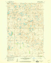
1958 Map of Goldwin SE
USGS Topo · Published 1959About this map
Glacial prairie potholes and small depressions define the character of the Stutsman County landscape during the late 1950s. The region is marked by a distinctive grid of township and section lines, with rural education hubs like School No 4 and School No 1 serving as central community points. The hydrology is dominated by water bodies such as Cottonwood Lake, Brush Lake, and Deer Lake, illustrating the complex drainage patterns of the Missouri River Basin development program. Larger terrain features like Paris, Round Top, and Spring Valley provide a sense of the local topography, while modern infrastructure begins to appear in the form of a Microwave Tower. This survey captures a specific moment in North Dakota's agricultural history when small, numbered school districts still anchored the rural townships before the widespread consolidation of the late 20th century.
Find a feature on this map
15 named features on this map. Tap any name to fly to it.
Don’t see what you’re looking for? This feature index may not catch every label — zoom into the map to look around manually.
Map Details
Editions of this 1958 Goldwin SE Map
2 editions found
Other maps of this area

1896 · Jamestown
USGS Topo · 1:125,000

1900 · Pingree
USGS Topo · 1:125,000

1900 · Pingree
USGS Topo · 1:62,500

1951 · Pingree
USGS Topo · 1:24,000

1951 · Eldridge NW
USGS Topo · 1:24,000

1952 · Pingree SW
USGS Topo · 1:24,000

1952 · New Rockford
USGS Topo · 1:250,000

1953 · Jamestown
USGS Topo · 1:250,000

1953 · Cleveland
USGS Topo · 1:24,000

1954 · Cleveland NW
USGS Topo · 1:24,000