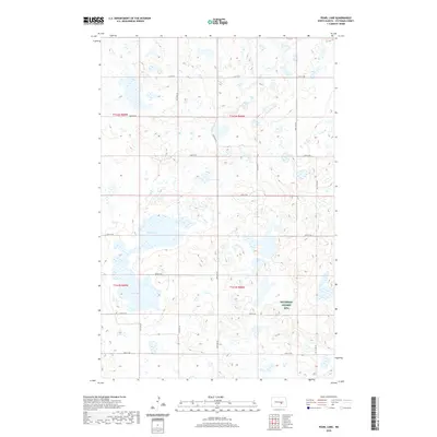
2020 Map of Pearl Lake
USGS Topo · Published 2020About this map
Pearl Lake and Mud Lake characterize this portion of the Missouri Coteau, where the landscape is defined by the high density of prairie potholes and wetlands typical of central North Dakota. This 2020 map of Stutsman County reveals a geography where water management and conservation are central to the landscape, specifically highlighted by the presence of the Stutsman County WPA, a Water Production Area dedicated to preserving habitat for migratory birds. The terrain is organized by a rigid grid of rural section roads, such as 56th Ave SE and 25th St SE, which serve the agricultural operations that surround these vital water bodies. The relationship between the natural drainage patterns and the surveyed section lines illustrates the ongoing balance between prairie wetland conservation and human land use in the Northern Plains.
Find a feature on this map
21 named features on this map. Tap any name to fly to it.
Don’t see what you’re looking for? This feature index may not catch every label — zoom into the map to look around manually.
Map Details
Editions of this 2020 Pearl Lake Map
This is the sole edition of this map. No revisions or reprints were ever made.
Other maps of this area

1952 · New Rockford
USGS Topo · 1:250,000

1953 · Jamestown
USGS Topo · 1:250,000

1954 · Cleveland NW
USGS Topo · 1:24,000

1954 · Medina
USGS Topo · 1:24,000

1955 · Crystal Springs
USGS Topo · 1:24,000

1956 · New Rockford
USGS Topo · 1:250,000

1956 · Jamestown
USGS Topo · 1:250,000
1958 · Goldwin SW
USGS Topo · 1:24,000

1958 · Goldwin
USGS Topo · 1:24,000

1971 · New Rockford
USGS Topo · 1:250,000