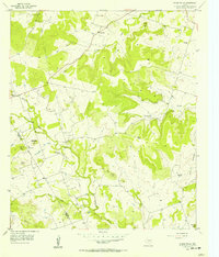
1956 Map of Pecan Wells
USGS Topo · Published 1957About this map
The Lampasas River snakes through the southern reaches of this landscape, defining a rural corridor along the Hamilton and Mills county line during the mid-1950s. The settlement pattern is characterized by small, dispersed communities and family landmarks, including Springdale and Pecan Wells. This era shows a transition in local infrastructure, notably evidenced by the McGirk Sch (Aband), reflecting shifts in rural education.
Find a feature on this map
24 named features on this map. Tap any name to fly to it.
Don’t see what you’re looking for? This feature index may not catch every label — zoom into the map to look around manually.
Map Details
Editions of this 1956 Pecan Wells Map
This is the sole edition of this map. No revisions or reprints were ever made.
Other maps of this area

1887 · Lampasas
USGS Topo · 1:125,000

1888 · Hamilton
USGS Topo · 1:125,000

1894 · Hamilton
USGS Topo · 1:125,000

1894 · Lampasas
USGS Topo · 1:125,000

1954 · Brownwood
USGS Topo · 1:250,000

1954 · Evant
USGS Topo · 1:62,500

1954 · Evant
USGS Topo · 1:24,000

1956 · Pottsville
USGS Topo · 1:62,500

1956 · Hamilton
USGS Topo · 1:62,500

1956 · Hamilton West
USGS Topo · 1:24,000