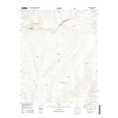
2013 Map of Pecos Falls
USGS Topo · Published 2013About this map
The Sangre de Cristo Mountains dominate this high-altitude landscape where the headwaters of the Pecos River begin their descent. This 2013 survey highlights the convergence of the Carson National Forest and Santa Fe National Forest, a terrain defined by sharp ridgelines and deep glacial basins. High peaks including Little Jicarita Peak and Chimayosos Peak stand as sentinels over the Rio Arriba and Mora county line, which follows the drainage divide. Isolated outposts like Beatty Cabin and Smith Cabin serve as rare markers of human presence in this wilderness, while the complex hydrology of the Rito Valdez, Rio Mora, and Middle Fork Rio Santa Barbara illustrates the critical role of these mountains in sourcing downstream water systems. The map also records alpine features like Middle Fork Lake and broad landforms such as Hamilton Mesa, which separate the various ritos and brooks that carve through the canyon systems.
Find a feature on this map
34 named features on this map. Tap any name to fly to it.
Don’t see what you’re looking for? This feature index may not catch every label — zoom into the map to look around manually.
Map Details
Editions of this 2013 Pecos Falls Map
This is the sole edition of this map. No revisions or reprints were ever made.
Other maps of this area

1889 · Las Vegas
USGS Topo · 1:125,000

1889 · Santa Fe
USGS Topo · 1:125,000

1891 · Las Vegas
USGS Topo · 1:125,000

1893 · Las Vegas
USGS Topo · 1:125,000

1894 · Santa Fe
USGS Topo · 1:125,000

1954 · Santa Fe
USGS Topo · 1:250,000

1954 · Raton
USGS Topo · 1:250,000

1958 · Raton
USGS Topo · 1:250,000

1958 · Santa Fe
USGS Topo · 1:250,000
1961 · Cowles
USGS Topo · 1:24,000