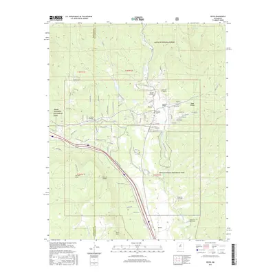
2017 Map of Pecos
USGS Topo · Published 2017About this map
Pecos and East Pecos serve as the central hubs in this high-altitude landscape where the Pecos River carves through the transition between the Santa Fe National Forest and the rugged edges of Glorieta Mesa. The map captures a detailed intersection of religious and cultural history, documented through sites like Old Saint Anthony's Church Cem and New Saint Anthonys Cem. Transportation corridors are well-defined, showing the BNSF Railway and the Old Denver Hwy skirting the western slopes of the valley near Rowe. Portions of Pecos National Historical Park are visible, protecting the vicinity's unique heritage. Notable terrain features including La Cueva Canyon, Cerro de Escobas, and Rowe Peak define the horizon, while smaller settlements like La Cueva and the tranquil Monastery Lake populate the river corridor.
Find a feature on this map
88 named features on this map. Tap any name to fly to it.
Don’t see what you’re looking for? This feature index may not catch every label — zoom into the map to look around manually.
Map Details
Editions of this 2017 Pecos Map
This is the sole edition of this map. No revisions or reprints were ever made.
Other maps of this area

1889 · Santa Fe
USGS Topo · 1:125,000

1894 · Santa Fe
USGS Topo · 1:125,000

1894 · Lamy
USGS Topo · 1:125,000

1953 · Glorieta
USGS Topo · 1:24,000

1953 · Mc Clure Reservoir
USGS Topo · 1:24,000

1954 · Santa Fe
USGS Topo · 1:250,000

1958 · Santa Fe
USGS Topo · 1:250,000

1961 · Honey Boy Ranch
USGS Topo · 1:24,000

1961 · Rosilla Peak
USGS Topo · 1:24,000
1961 · Pecos
USGS Topo · 1:24,000