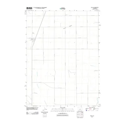
2010 Map of Peetz
USGS Topo · Published 2010About this map
Peetz stands as the primary settlement on this Logan County survey, situated at the intersection of County Hwy 55 and County Rd 74. The landscape is dominated by the broad, elevated terrain of Peetz Table, which dictates the drainage patterns for the surrounding prairie. A network of ephemeral waterways, including Cow Creek, Cottonwood Creek, and Corral Creek, carves through the landscape, while the North Sterling Outlet Canal cuts through the southeastern corner, signifying the region's managed water infrastructure. Genealogists and local historians will find the Peetz Cemetery located north of the town center, a key landmark for tracing family roots in this agricultural community. The map illustrates a highly organized grid of county roads, such as County Rd 76 and County Rd 53, which provide access across the high plains and connect the various reaches of East Lewis Creek.
Find a feature on this map
26 named features on this map. Tap any name to fly to it.
Don’t see what you’re looking for? This feature index may not catch every label — zoom into the map to look around manually.
Map Details
Editions of this 2010 Peetz Map
This is the sole edition of this map. No revisions or reprints were ever made.
Other maps of this area

1899 · Sidney
USGS Topo · 1:125,000

1951 · Iliff
USGS Topo · 1:24,000

1951 · Padroni NW
USGS Topo · 1:24,000

1952 · Padroni
USGS Topo · 1:24,000

1953 · Peetz
USGS Topo · 1:24,000

1953 · Proctor
USGS Topo · 1:24,000

1953 · Haystack Butte
USGS Topo · 1:24,000

1954 · Sterling
USGS Topo · 1:250,000

1954 · Scottsbluff
USGS Topo · 1:250,000

1958 · Scottsbluff
USGS Topo · 1:250,000