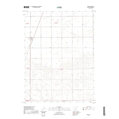
2019 Map of Peetz
USGS Topo · Published 2019About this map
Peetz serves as the central hub of this agricultural landscape in Logan County, defined by a neat grid of county roads and intermittent waterways. The town's layout is clearly delineated with its primary thoroughfares, including Shaw Ave and Logan St, situated just south of the Peetz Cem. This 2019 survey illustrates the persistent importance of water management in the high plains, as several drainages such as Cow Cr, Cottonwood Cr, and Corral Cr snake through the sections, contrasting the rigid lines of the surrounding section boundaries. To the southwest, the headwaters of E Lewis Cr begin to carve into the terrain, showing the subtle topographical shifts that dictate the flow of runoff through these townships. The map records the intersection of modern road infrastructure like Co RD 74 with the traditional land survey system of northeastern Colorado.
Find a feature on this map
24 named features on this map. Tap any name to fly to it.
Don’t see what you’re looking for? This feature index may not catch every label — zoom into the map to look around manually.
Map Details
Editions of this 2019 Peetz Map
This is the sole edition of this map. No revisions or reprints were ever made.
Other maps of this area

1899 · Sidney
USGS Topo · 1:125,000

1951 · Iliff
USGS Topo · 1:24,000

1951 · Padroni NW
USGS Topo · 1:24,000

1952 · Padroni
USGS Topo · 1:24,000

1953 · Peetz
USGS Topo · 1:24,000

1953 · Proctor
USGS Topo · 1:24,000

1953 · Haystack Butte
USGS Topo · 1:24,000

1954 · Sterling
USGS Topo · 1:250,000

1954 · Scottsbluff
USGS Topo · 1:250,000

1958 · Scottsbluff
USGS Topo · 1:250,000