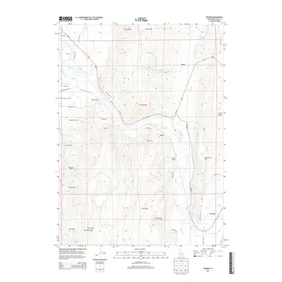
2013 Map of Pegram
USGS Topo · Published 2013About this map
Pegram and Harer sit along the eastern corridor of the Bear River, illustrating the high-desert agricultural and rail infrastructure of Bear Lake County. The landscape is defined by an intricate network of irrigation systems including the Montpelier Preston Canal, Black Otter Canal, and Nuffer Canal, which draw from the river to support local ranching. Further west, the terrain rises into the Preuss Range, where numerous hollows such as Dam Hollow and First Hollow cut through the hills. This 2013 survey preserves the locations of rural landmarks like Bennetts Spring and the Sheep Cr Reservoir, while road names like Cemetary Rd and Old Highway 30 point to the area's historical transportation and community foundations. Small settlements like Dingle and Alton remain connected by the valley floor's rail and road grid beneath the prominent Sheep Creek Hills.
Find a feature on this map
47 named features on this map. Tap any name to fly to it.
Don’t see what you’re looking for? This feature index may not catch every label — zoom into the map to look around manually.
Map Details
Editions of this 2013 Pegram Map
This is the sole edition of this map. No revisions or reprints were ever made.
Other maps of this area

1909 · Montpelier
USGS Topo · 1:125,000

1911 · Montpelier
USGS Topo · 1:125,000

1955 · Preston
USGS Topo · 1:250,000

1958 · Preston
USGS Topo · 1:250,000

1962 · Preston
USGS Topo · 1:250,000

1967 · Montpelier
USGS Topo · 1:24,000

1967 · Dingle
USGS Topo · 1:24,000
1970 · Border
USGS Topo · 1:24,000
1970 · Bear Lake North
USGS Topo · 1:24,000
1970 · Boundary Ridge
USGS Topo · 1:24,000