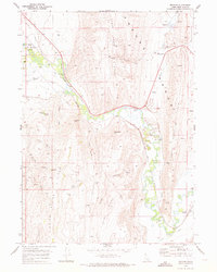
1970 Map of Pegram
USGS Topo · Published 1973About this map
The Bear River meanders through this portion of Bear Lake County, Idaho, where a complex network of irrigation works such as the Crockett Canal, Ream Canal, and Sorensen Ditch define the valley floor. The Union Pacific railroad tracks follow the river's path, connecting small sidings and communities like Dingle (Siding) and Pegram. This landscape is marked by the transition from the flat, water-rich bottomlands to the sharp rises of the Preuss Range and the Sheep Creek Hills.
Find a feature on this map
52 named features on this map. Tap any name to fly to it.
Don’t see what you’re looking for? This feature index may not catch every label — zoom into the map to look around manually.
Map Details
Editions of this 1970 Pegram Map
This is the sole edition of this map. No revisions or reprints were ever made.
Other maps of this area

1909 · Montpelier
USGS Topo · 1:125,000

1911 · Montpelier
USGS Topo · 1:125,000

1955 · Preston
USGS Topo · 1:250,000

1958 · Preston
USGS Topo · 1:250,000

1962 · Preston
USGS Topo · 1:250,000

1967 · Montpelier
USGS Topo · 1:24,000

1967 · Dingle
USGS Topo · 1:24,000
1970 · Border
USGS Topo · 1:24,000
1970 · Bear Lake North
USGS Topo · 1:24,000
1970 · Boundary Ridge
USGS Topo · 1:24,000