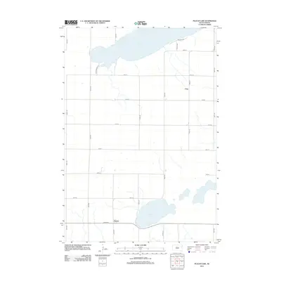
2012 Map of Pelican Lake
USGS Topo · Published 2012About this map
Pelican Lake and Clear Lake dominate the northern and southern landscape of this Glacial Lakes region, south of Watertown. This 2012 survey illustrates the grid-like agricultural settlement pattern characteristic of Codington County, where local life centers around small unincorporated communities and family farms. The tiny settlement of Foley sits along the eastern edge, while Thomas serves as a southern waypoint near the shores of Clear Lake. Genealogists and local historians can find the Oxford Cem located just west of Thomas, marking a critical site for tracing the area's rural heritage. The network of section-line roads, such as 451st Ave and 177th St, reflects the systematic land division that has defined South Dakota's prairie development since the homesteading era.
Find a feature on this map
19 named features on this map. Tap any name to fly to it.
Don’t see what you’re looking for? This feature index may not catch every label — zoom into the map to look around manually.
Map Details
Editions of this 2012 Pelican Lake Map
This is the sole edition of this map. No revisions or reprints were ever made.
Other maps of this area

1953 · Watertown
USGS Topo · 1:250,000

1958 · Watertown
USGS Topo · 1:250,000

1969 · Hayti
USGS Topo · 1:24,000

1969 · Castlewood
USGS Topo · 1:24,000

1969 · Watertown West
USGS Topo · 1:24,000

1969 · Pelican Lake
USGS Topo · 1:24,000

1969 · Watertown SE
USGS Topo · 1:24,000

1969 · Watertown East
USGS Topo · 1:24,000

1973 · Bryant NE
USGS Topo · 1:24,000
1973 · Kampeska
USGS Topo · 1:24,000