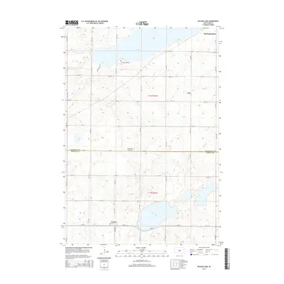
2015 Map of Pelican Lake
USGS Topo · Published 2015About this map
Pelican Lake and Clear Lake dominate this landscape on the Coteau des Prairies plateau, where the glacial geography of eastern South Dakota is clearly defined by these significant water bodies. The terrain is marked by the transition between Codington and Hamlin counties, featuring a regular grid of section roads like 451st Ave and 178th St that partition the agricultural land. In the southern portion of the quadrangle, the small settlement of Thomas sits near the Oxford Cem, providing a focal point for genealogical research in this rural area. Further north, the southern edges of Watertown and the locality of Foley appear, connected by routes such as Thompson Point Rd. The map illustrates the contemporary balance between protected recreational spaces like Pelican State Park Rd and the enduring township-and-range layout of the prairie.
Find a feature on this map
27 named features on this map. Tap any name to fly to it.
Don’t see what you’re looking for? This feature index may not catch every label — zoom into the map to look around manually.
Map Details
Editions of this 2015 Pelican Lake Map
This is the sole edition of this map. No revisions or reprints were ever made.
Other maps of this area

1953 · Watertown
USGS Topo · 1:250,000

1958 · Watertown
USGS Topo · 1:250,000

1969 · Hayti
USGS Topo · 1:24,000

1969 · Castlewood
USGS Topo · 1:24,000

1969 · Watertown West
USGS Topo · 1:24,000

1969 · Pelican Lake
USGS Topo · 1:24,000

1969 · Watertown SE
USGS Topo · 1:24,000

1969 · Watertown East
USGS Topo · 1:24,000

1973 · Bryant NE
USGS Topo · 1:24,000
1973 · Kampeska
USGS Topo · 1:24,000