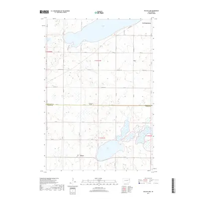
2017 Map of Pelican Lake
USGS Topo · Published 2017About this map
Coteau des Prairies defines the rolling elevation of this landscape, where the southern reaches of Watertown meet the rural expanses of the Glacial Lakes region. The map captures a transition between the developing outskirts of the city and the small-scale agricultural settlements of Foley and Thomas. These areas are characterized by a dense grid of county roads, such as Co Rd 17A and Codington Co 11, which connect isolated homesteads to the region's prominent water bodies. Pelican Lake dominates the northern border, while Clear Lake and the cluster known as Five Ponds mark the southern topography. For local historians and genealogists, the presence of the Oxford Cem near Thomas provides a specific point of interest for family research within this prairie landscape, illustrating the enduring footprint of early pioneer communities in Codington and Hamlin counties.
Find a feature on this map
38 named features on this map. Tap any name to fly to it.
Don’t see what you’re looking for? This feature index may not catch every label — zoom into the map to look around manually.
Map Details
Editions of this 2017 Pelican Lake Map
This is the sole edition of this map. No revisions or reprints were ever made.
Other maps of this area

1953 · Watertown
USGS Topo · 1:250,000

1958 · Watertown
USGS Topo · 1:250,000

1969 · Hayti
USGS Topo · 1:24,000

1969 · Castlewood
USGS Topo · 1:24,000

1969 · Watertown West
USGS Topo · 1:24,000

1969 · Pelican Lake
USGS Topo · 1:24,000

1969 · Watertown SE
USGS Topo · 1:24,000

1969 · Watertown East
USGS Topo · 1:24,000

1973 · Bryant NE
USGS Topo · 1:24,000
1973 · Kampeska
USGS Topo · 1:24,000