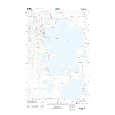
2013 Map of Pelican Lake
USGS Topo · Published 2013About this map
Breezy Point serves as the focal point of this recreational landscape, characterized by an intricate network of waterways and glacial lakes in Crow Wing County. The settlement patterns shown here reflect a deep-rooted resort culture, with the Breezy Point Airport and the Traditional Eighteen Hole Golf Course situated prominently on the peninsula. The massive expanse of Pelican Lake dominates the center of the sheet, featuring Gooseberry Island and connecting toward smaller basins like Little Pelican Lake and Lake Edward. To the south, the Shing Wako Resort and Campground suggests the long-standing importance of seasonal tourism to the local economy. The terrain is marked by dozens of distinct water bodies, from Ossawinnamakee Lake in the north to Rice Lake and Silver Lake at the southern margin, illustrating the complex hydrology that has shaped land use and property boundaries throughout the region.
Find a feature on this map
106 named features on this map. Tap any name to fly to it.
Don’t see what you’re looking for? This feature index may not catch every label — zoom into the map to look around manually.
Map Details
Editions of this 2013 Pelican Lake Map
This is the sole edition of this map. No revisions or reprints were ever made.
Other maps of this area

1915 · Brainerd
USGS Topo · 1:62,500

1916 · Pillager
USGS Topo · 1:62,500

1918 · Brainerd
USGS Topo · 1:62,500

1919 · Pillager
USGS Topo · 1:62,500

1953 · Brainerd
USGS Topo · 1:250,000

1957 · Brainerd
USGS Topo · 1:250,000

1958 · Brainerd
USGS Topo · 1:250,000

1959 · Trommald
USGS Topo · 1:24,000

1959 · Pelican Lake
USGS Topo · 1:24,000

1959 · Nisswa
USGS Topo · 1:24,000