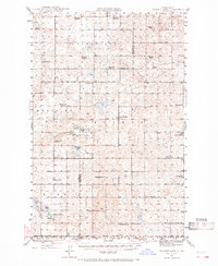
1945 Map of Pelican Lake
USGS Topo · Published 1968About this map
Glacial prairie potholes and an extensive network of rural school districts define this mid-century landscape straddling the McLean Co and Sheridan Co line. The terrain is dominated by water bodies such as Pelican Lake, Cherry Lake, and Brush Lake, around which a dense system of local education was organized. The map reveals the granularity of the township system, with numerous numbered facilities like Byersville Sch No 4 and Medicine Hill Sch No 4 serving the scattered farming community.
Find a feature on this map
38 named features on this map. Tap any name to fly to it.
Don’t see what you’re looking for? This feature index may not catch every label — zoom into the map to look around manually.
Map Details
Editions of this 1945 Pelican Lake Map
3 editions found
Other maps of this area

1929 · Kongsberg
USGS Topo · 1:62,500

1929 · Balfour
USGS Topo · 1:62,500

1930 · Drake
USGS Topo · 1:62,500

1945 · Pelican Lake
USGS Topo · 1:62,500

1947 · Pelican Lake
USGS Topo · 1:62,500

1947 · Turtle Lake
USGS Topo · 1:62,500

1947 · Lincoln Valley
USGS Topo · 1:62,500

1949 · Turtle Creek
USGS Topo · 1:62,500

1954 · McClusky
USGS Topo · 1:250,000

1958 · McClusky
USGS Topo · 1:250,000