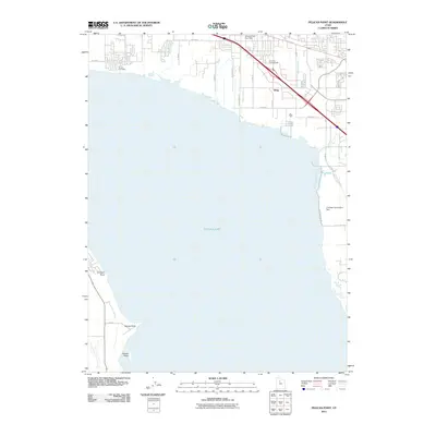
2011 Map of Pelican Point
USGS Topo · Published 2011About this map
Utah Lake dominates this landscape, its western and northern shores defining the transition between the freshwater basin and the growing suburban grid of northern Utah County. By the early 21st century, the northern shore shows significant development, with the American Fork Post Office and Draper Post Office serving established residential clusters. The industrial history of the shoreline is grounded by the U S Steel Corporation Dam on the eastern edge of the lake, while the settlement of Wing sits near the crossing of the interstate and rail corridor. To the south, the topography remains less developed, marked by prominent landforms such as Pelican Point, Goose Point, and Jumbers Point. This area reveals a complex water management system necessary for the region's agriculture and industry, including the Mcarthur Ditch and the Lake Bottom Canal.
Find a feature on this map
29 named features on this map. Tap any name to fly to it.
Don’t see what you’re looking for? This feature index may not catch every label — zoom into the map to look around manually.
Map Details
Editions of this 2011 Pelican Point Map
This is the sole edition of this map. No revisions or reprints were ever made.
Other maps of this area

1885 · Salt Lake
USGS Topo · 1:250,000

1948 · Timpanogos Cave
USGS Topo · 1:24,000

1948 · Orem
USGS Topo · 1:24,000

1948 · Orem
USGS Topo · 1:62,500

1948 · Provo
USGS Topo · 1:24,000

1949 · Provo
USGS Topo · 1:62,500

1950 · Orem
USGS Topo · 1:24,000

1950 · Timpanogos Cave
USGS Topo · 1:24,000

1950 · Provo
USGS Topo · 1:24,000
1950 · Soldiers Pass
USGS Topo · 1:24,000