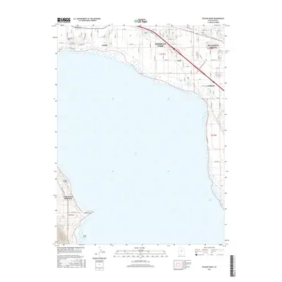
2017 Map of Pelican Point
USGS Topo · Published 2017About this map
Utah Lake dominates the central expanse of this region, serving as the focal point for the developing communities along its northern and eastern shores. In the late 2010s, the urban interface of Saratoga Springs to the west and the contiguous growth of Lehi, American Fork, and Pleasant Grove to the north reflects the rapid transformation of Utah County. Irrigation and water management remain visible through features like the McArthur Ditch and Lake Bottom Canal, hinting at the area's agricultural foundations that preceded suburban expansion. Along the shoreline, distinct geographical markers such as Pelican Point, Goose Point, and Jumbers Point define the lake's edge, while the historic rail corridor of Bamberger Dr provides a nod to the region's earlier transportation history.
Find a feature on this map
48 named features on this map. Tap any name to fly to it.
Don’t see what you’re looking for? This feature index may not catch every label — zoom into the map to look around manually.
Map Details
Editions of this 2017 Pelican Point Map
This is the sole edition of this map. No revisions or reprints were ever made.
Other maps of this area

1885 · Salt Lake
USGS Topo · 1:250,000

1948 · Timpanogos Cave
USGS Topo · 1:24,000

1948 · Orem
USGS Topo · 1:24,000

1948 · Orem
USGS Topo · 1:62,500

1948 · Provo
USGS Topo · 1:24,000

1949 · Provo
USGS Topo · 1:62,500

1950 · Orem
USGS Topo · 1:24,000

1950 · Timpanogos Cave
USGS Topo · 1:24,000

1950 · Provo
USGS Topo · 1:24,000
1950 · Soldiers Pass
USGS Topo · 1:24,000