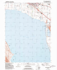
1992 Map of Pelican Point
USGS Topo · Published 1992About this map
The northeastern shores of Utah Lake dominate this 1992 revision, documenting a landscape where urban expansion meets industrial and conservation land use. The burgeoning communities of American Fork and Pleasant Grove are mapped in detail, showing a grid of residential streets reaching toward the water's edge, including the Greenwood Sch and Botany Park. Transport and utility infrastructure is heavily represented, with the path of Interstate 15 and Highway 89 passing through Wing, alongside a large Sewage Disposal plant and industrial Vineyard corporate boundaries.
Find a feature on this map
31 named features on this map. Tap any name to fly to it.
Don’t see what you’re looking for? This feature index may not catch every label — zoom into the map to look around manually.
Map Details
Editions of this 1992 Pelican Point Map
This is the sole edition of this map. No revisions or reprints were ever made.
Other maps of this area

1885 · Salt Lake
USGS Topo · 1:250,000

1948 · Timpanogos Cave
USGS Topo · 1:24,000

1948 · Orem
USGS Topo · 1:24,000

1948 · Orem
USGS Topo · 1:62,500

1948 · Provo
USGS Topo · 1:24,000

1949 · Provo
USGS Topo · 1:62,500

1950 · Orem
USGS Topo · 1:24,000

1950 · Timpanogos Cave
USGS Topo · 1:24,000

1950 · Provo
USGS Topo · 1:24,000
1950 · Soldiers Pass
USGS Topo · 1:24,000