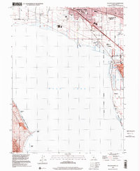
1999 Map of Pelican Point
USGS Topo · Published 2001About this map
Utah Lake dominates this late-twentieth-century landscape, framing the growing municipal boundaries of the Utah Valley. The map documents the northern and eastern shorelines as they appeared in 1999, capturing the urban interface of American Fork, Pleasant Grove, and Lindon. Industrial and environmental features are prominent, such as the Cooling Pond and the nearby Slag Dump at Vineyard, illustrating the legacy of local manufacturing. Natural preservation is noted at the Powell Slough State Waterfowl Management Area, which borders the water. Community infrastructure is well-defined, including Greenwood Sch and several local recreation spots like Mountain Meadows Park and a Racetrack. The western shore is characterized by more isolated terrain, marked by Pelican Point, Goose Point, and Jumbers Point along the Saratoga Springs Corporate Boundary.
Find a feature on this map
34 named features on this map. Tap any name to fly to it.
Don’t see what you’re looking for? This feature index may not catch every label — zoom into the map to look around manually.
Map Details
Editions of this 1999 Pelican Point Map
This is the sole edition of this map. No revisions or reprints were ever made.
Other maps of this area

1885 · Salt Lake
USGS Topo · 1:250,000

1948 · Timpanogos Cave
USGS Topo · 1:24,000

1948 · Orem
USGS Topo · 1:24,000

1948 · Orem
USGS Topo · 1:62,500

1948 · Provo
USGS Topo · 1:24,000

1949 · Provo
USGS Topo · 1:62,500

1950 · Orem
USGS Topo · 1:24,000

1950 · Timpanogos Cave
USGS Topo · 1:24,000

1950 · Provo
USGS Topo · 1:24,000
1950 · Soldiers Pass
USGS Topo · 1:24,000