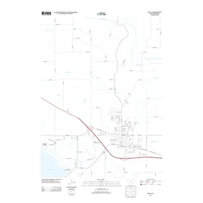
2013 Map of Pella
USGS Topo · Published 2013About this map
Pella stands as a significant cultural and civic hub in this early 21st-century landscape, defined by its orderly grid and Dutch heritage landmarks like the Tulip Toren. The city is framed by a transition from industrial and municipal development, such as the Pella Municipal Airport and Ryerson Golf Range, to the expansive shoreline of Lake Red Rock in the southwest. The surrounding countryside is dissected by numerous waterways including the S Skunk River to the north and the meandering paths of Thunder Cr and Lighting Cr. This survey illustrates the modern expansion of the area, where historical road corridors like Dubuque St and Erbe St meet newer developments and recreational sites such as Wallashuck Campground, capturing the balance between the township's established center and its varied agricultural and riparian borders.
Find a feature on this map
115 named features on this map. Tap any name to fly to it.
Don’t see what you’re looking for? This feature index may not catch every label — zoom into the map to look around manually.
Map Details
Editions of this 2013 Pella Map
This is the sole edition of this map. No revisions or reprints were ever made.
Other maps of this area

1909 · Knoxville
USGS Topo · 1:62,500

1910 · Pella
USGS Topo · 1:62,500

1912 · Knoxville
USGS Topo · 1:62,500

1912 · Pella
USGS Topo · 1:62,500

1954 · Des Moines
USGS Topo · 1:250,000

1956 · Des Moines
USGS Topo · 1:250,000

1957 · Des Moines
USGS Topo · 1:250,000

1965 · Monroe
USGS Topo · 1:24,000
1965 · Otley
USGS Topo · 1:24,000
1965 · Knoxville
USGS Topo · 1:24,000