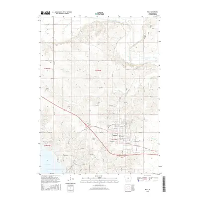
2015 Map of Pella
USGS Topo · Published 2015About this map
Pella stands at the center of this 2015 landscape, where the residential and commercial blocks of the city meet the educational grounds of Central Coll. The map records a transition from the structured urban grid to the surrounding farmsteads of Marion County, defined by several historical burial sites including Oak Wood Cem, Graceland Cem, and Saint Mary's Cem. The local geography is heavily influenced by the winding course of the South Skunk River in the northeast and the northeastern tip of Lake Red Rock in the southwest.
Find a feature on this map
105 named features on this map. Tap any name to fly to it.
Don’t see what you’re looking for? This feature index may not catch every label — zoom into the map to look around manually.
Map Details
Editions of this 2015 Pella Map
This is the sole edition of this map. No revisions or reprints were ever made.
Other maps of this area

1909 · Knoxville
USGS Topo · 1:62,500

1910 · Pella
USGS Topo · 1:62,500

1912 · Knoxville
USGS Topo · 1:62,500

1912 · Pella
USGS Topo · 1:62,500

1954 · Des Moines
USGS Topo · 1:250,000

1956 · Des Moines
USGS Topo · 1:250,000

1957 · Des Moines
USGS Topo · 1:250,000

1965 · Monroe
USGS Topo · 1:24,000
1965 · Otley
USGS Topo · 1:24,000
1965 · Knoxville
USGS Topo · 1:24,000