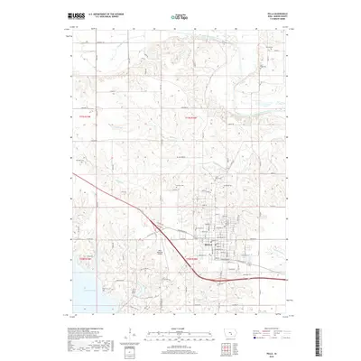
2018 Map of Pella
USGS Topo · Published 2018About this map
The Dutch-heritage city of Pella serves as the focal point of this 2018 survey, showcasing the community's expansion between the South Skunk River to the north and the expansive Lake Red Rock to the southwest. The landscape is defined by the drainage patterns of several local tributaries, including Lighting Cr, Thunder Cr, and Muchakinock Cr, which carve through the Iowa plains. For genealogists, the map is particularly valuable for its precise locations of numerous rural burial grounds such as Tlam Cem, Sand Ridge Cem, and Parsons Cem dotting the township lines.
Find a feature on this map
93 named features on this map. Tap any name to fly to it.
Don’t see what you’re looking for? This feature index may not catch every label — zoom into the map to look around manually.
Map Details
Editions of this 2018 Pella Map
This is the sole edition of this map. No revisions or reprints were ever made.
Other maps of this area

1909 · Knoxville
USGS Topo · 1:62,500

1910 · Pella
USGS Topo · 1:62,500

1912 · Knoxville
USGS Topo · 1:62,500

1912 · Pella
USGS Topo · 1:62,500

1954 · Des Moines
USGS Topo · 1:250,000

1956 · Des Moines
USGS Topo · 1:250,000

1957 · Des Moines
USGS Topo · 1:250,000

1965 · Monroe
USGS Topo · 1:24,000
1965 · Otley
USGS Topo · 1:24,000
1965 · Knoxville
USGS Topo · 1:24,000