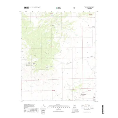
2020 Map of Pelona Mountain
USGS Topo · Published 2020About this map
Pelona Mtn dominates the center of this high-elevation landscape in Catron County, where the Continental Divide winds through the southwestern reaches of the Gila National Forest. The map documents a complex system of canyon drainage and water management, featuring a network of livestock tanks and springs vital to this arid environment. Significant features include Juanita Canyon in the north and the winding Fullerton Spring Canyon, which leads toward the high peaks. The topography is also defined by the Continental Divide National Scenic Trail, which traverses the terrain from the south toward the northeast. This 2020 survey provides a look at the modern state of these public lands, showing the intersection of natural landmarks like Prairie Lake with the cadastral boundaries of the New Mexico principal meridian.
Find a feature on this map
27 named features on this map. Tap any name to fly to it.
Don’t see what you’re looking for? This feature index may not catch every label — zoom into the map to look around manually.
Map Details
Editions of this 2020 Pelona Mountain Map
This is the sole edition of this map. No revisions or reprints were ever made.
Other maps of this area

1918 · Pelona
USGS Topo · 1:125,000

1954 · Tularosa
USGS Topo · 1:250,000

1954 · Clifton
USGS Topo · 1:250,000

1957 · Clifton
USGS Topo · 1:250,000

1958 · Clifton
USGS Topo · 1:250,000

1958 · Tularosa
USGS Topo · 1:250,000

1962 · Clifton
USGS Topo · 1:250,000

1979 · San Mateo Mountains
USGS Topo · 1:100,000

1981 · Fullerton
USGS Topo · 1:24,000
1981 · Pelona Mountain
USGS Topo · 1:24,000