
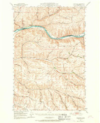
1950 Map of Penawawa
USGS Topo · Published 1952About this map
The Snake River carves a deep path through this 1950s landscape, serving as the border between Whitman and Garfield counties. The map illustrates a river-centered economy and geography prior to major dam projects, where alluvial bars like Rice Bar and Swift Bar were prominent enough to support small settlements and river crossings. Small communities such as Penawawa and Rice sit directly on the riverbanks, connected by the Union Pacific railroad line that follows the northern shore through Penawawa Canyon.
Find a feature on this map
44 named features on this map. Tap any name to fly to it.
Don’t see what you’re looking for? This feature index may not catch every label — zoom into the map to look around manually.
Map Details
Editions of this 1950 Penawawa Map
2 editions found
Other maps of this area

1910 · Pullman
USGS Topo · 1:125,000

1937 · Pomeroy
USGS Topo · 1:96,000

1942 · Pomeroy
USGS Topo · 1:125,000

1943 · Peola
USGS Topo · 1:62,500

1946 · Peola
USGS Topo · 1:62,500

1950 · La Crosse
USGS Topo · 1:62,500

1950 · Endicott
USGS Topo · 1:62,500

1950 · Hay
USGS Topo · 1:62,500

1952 · Hay
USGS Topo · 1:62,500

1952 · La Crosse
USGS Topo · 1:62,500