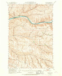
1950 Map of Penawawa
USGS Topo · Published 1967About this map
The Snake River carves a deep path through this portion of southeastern Washington, separating Whitman and Garfield counties. Along the northern banks, the small settlement of Penawawa sits near a bend in the river, adjacent to the U P & N P RR tracks and a local Cem. The landscape is defined by its series of river bars, including Rice Bar, Swift, and Schultz Bar, which provided critical flat ground for early activity before the valley's later inundation by dam projects.
Find a feature on this map
59 named features on this map. Tap any name to fly to it.
Don’t see what you’re looking for? This feature index may not catch every label — zoom into the map to look around manually.
Map Details
Editions of this 1950 Penawawa Map
2 editions found
Other maps of this area

1910 · Pullman
USGS Topo · 1:125,000

1937 · Pomeroy
USGS Topo · 1:96,000

1942 · Pomeroy
USGS Topo · 1:125,000

1943 · Peola
USGS Topo · 1:62,500

1946 · Peola
USGS Topo · 1:62,500

1950 · La Crosse
USGS Topo · 1:62,500

1950 · Penawawa
USGS Topo · 1:62,500

1950 · Endicott
USGS Topo · 1:62,500

1950 · Hay
USGS Topo · 1:62,500

1952 · Hay
USGS Topo · 1:62,500